![](/images/other/stat-length.png)
![Tour Mountainbike La Bruffière - Circuit des étangs - long - La Bruffière - Photo](https://media.geolcdn.com/t/1900/400/ext.pjpeg?maxdim=2&url=https%3A%2F%2Fservices.sitytrail.com%2FGeolivesWS%2FDownloadMedia.ashx%3FTrailID%3D317512%26Media%3D16751_3.jpg)
Circuit des étangs - long - La Bruffière
tracegps
Benutzer
![Länge](/images/other/stat-length.png)
Länge
22 km
![Maximale Höhe](https://static1.geolcdn.com/siteimages/upload/files/1508320355ic_sort_altitude_max_24dp.png)
Maximale Höhe
92 m
![Positive Höhendifferenz](https://static1.geolcdn.com/siteimages/upload/files/1508320355ic_sort_den_pos_24dp.png)
Positive Höhendifferenz
122 m
![Km-Effort](/images/other/stat-length.png)
Km-Effort
23 km
![Min. Höhe](https://static1.geolcdn.com/siteimages/upload/files/1508320355ic_sort_altitude_min_24dp.png)
Min. Höhe
54 m
![Negative Höhendifferenz](https://static1.geolcdn.com/siteimages/upload/files/1508320355ic_sort_den_neg_24dp.png)
Negative Höhendifferenz
119 m
![Boucle](https://static1.geolcdn.com/siteimages/upload/files/16400158638029165_repeat_loop_refresh_sync_direction_icon.png)
Boucle
Ja
Erstellungsdatum :
2014-12-10 00:00:00.0
Letzte Änderung :
2014-12-10 00:00:00.0
![Mountainbike](https://static1.geolcdn.com/sitytour/trail-icons/202.png)
1h49
Schwierigkeit : Medium
![Scannen Sie diesen QR-Code, um die Tour in der SityTrail-Anwendung zu öffnen](https://capi.geolives.com/qq0zvz2zws4bq2lad0pu/sitytour/trails/317512/qr.png?size=200)
Kostenlosegpshiking-Anwendung
Über SityTrail
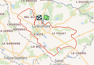
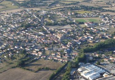
Tour Mountainbike von 22 km verfügbar auf Pays de la Loire, Vendée, La Bruffière. Diese Tour wird von tracegps vorgeschlagen.
Beschreibung
Départ du stade, rue du stade. Le circuitemprunte de nombreux chemins de remembrement et de section de routes, soyez vigilants aux abords des CD 77 et 753. Retrouvez le circuit sur le site de la commune de La Bruffière.
Ort
Land:
France
Region :
Pays de la Loire
Abteilung/Provinz :
Vendée
Kommune :
La Bruffière
Standort:
Unknown
Gehen Sie:(Dec)
Gehen Sie:(UTM)
637252 ; 5208520 (30T) N.
Kommentare
Touren in der Umgebung
![Tour Zu Fuß Boussay - Les Rochers - Photo](https://media.geolcdn.com/t/375/260/3ecea909-2cb0-40d7-a89a-0b1bd73102e1.jpeg&format=jpg&maxdim=2)
![Zu Fuß Zu Fuß](https://static1.geolcdn.com/sitytour/trail-icons/100.png)
Les Rochers
Zu Fuß
Einfach
Boussay,
Pays de la Loire,
Loire-Atlantique,
France
![](/images/other/stat-length.png)
12,1 km | 13,8 km-effort
3h 7min
![](https://static1.geolcdn.com/siteimages/upload/files/16400158638029165_repeat_loop_refresh_sync_direction_icon.png)
Ja
![Tour Wandern La Bruffière - boucle Boussay Hucheloup - Photo](https://media.geolcdn.com/t/375/260/ea114df9-7e90-42f6-b74a-1bf920b6e24a.jpg&format=jpg&maxdim=2)
![Wandern Wandern](https://static1.geolcdn.com/sitytour/trail-icons/101.png)
boucle Boussay Hucheloup
Wandern
Medium
La Bruffière,
Pays de la Loire,
Vendée,
France
![](/images/other/stat-length.png)
17,4 km | 21 km-effort
3h 59min
![](https://static1.geolcdn.com/siteimages/upload/files/16400158638029165_repeat_loop_refresh_sync_direction_icon.png)
Ja
![Tour Mountainbike La Bruffière - Circuit de la Sèvre Nantaise - La Bruffière - Photo](https://media.geolcdn.com/t/375/260/ext.jpg?maxdim=2&url=https%3A%2F%2Fservices.sitytrail.com%2FGeolivesWS%2FDownloadMedia.ashx%3FTrailID%3D317514%26Media%3D16753_6.jpg)
![Mountainbike Mountainbike](https://static1.geolcdn.com/sitytour/trail-icons/202.png)
Circuit de la Sèvre Nantaise - La Bruffière
Mountainbike
Medium
La Bruffière,
Pays de la Loire,
Vendée,
France
![](/images/other/stat-length.png)
25 km | 29 km-effort
2h 0min
![](https://static1.geolcdn.com/siteimages/upload/files/16400158638029165_repeat_loop_refresh_sync_direction_icon.png)
Ja
![Tour Mountainbike La Bruffière - Circuit des hameaux - La Bruffière - Photo](https://media.geolcdn.com/t/375/260/ext.jpg?maxdim=2&url=https%3A%2F%2Fservices.sitytrail.com%2FGeolivesWS%2FDownloadMedia.ashx%3FTrailID%3D317513%26Media%3D16752_3.jpg)
![Mountainbike Mountainbike](https://static1.geolcdn.com/sitytour/trail-icons/202.png)
Circuit des hameaux - La Bruffière
Mountainbike
Medium
La Bruffière,
Pays de la Loire,
Vendée,
France
![](/images/other/stat-length.png)
23 km | 25 km-effort
2h 0min
![](https://static1.geolcdn.com/siteimages/upload/files/16400158638029165_repeat_loop_refresh_sync_direction_icon.png)
Ja
![Tour Mountainbike La Bruffière - Circuit des étangs - court - La Bruffière - Photo](https://media.geolcdn.com/t/375/260/ext.jpg?maxdim=2&url=https%3A%2F%2Fservices.sitytrail.com%2FGeolivesWS%2FDownloadMedia.ashx%3FTrailID%3D317511%26Media%3D16750_4.jpg)
![Mountainbike Mountainbike](https://static1.geolcdn.com/sitytour/trail-icons/202.png)
Circuit des étangs - court - La Bruffière
Mountainbike
Einfach
La Bruffière,
Pays de la Loire,
Vendée,
France
![](/images/other/stat-length.png)
14,6 km | 15,8 km-effort
1h 19min
![](https://static1.geolcdn.com/siteimages/upload/files/16400158638029165_repeat_loop_refresh_sync_direction_icon.png)
Ja
![Tour Wandern La Bruffière - Circuit des châtelaines - La Bruffière - Photo](https://media.geolcdn.com/t/375/260/ext.jpg?maxdim=2&url=https%3A%2F%2Fservices.sitytrail.com%2FGeolivesWS%2FDownloadMedia.ashx%3FTrailID%3D317510%26Media%3D16749_6.jpg)
![Wandern Wandern](https://static1.geolcdn.com/sitytour/trail-icons/101.png)
Circuit des châtelaines - La Bruffière
Wandern
Schwierig
La Bruffière,
Pays de la Loire,
Vendée,
France
![](/images/other/stat-length.png)
15 km | 17,2 km-effort
3h 45min
![](https://static1.geolcdn.com/siteimages/upload/files/16400158638029165_repeat_loop_refresh_sync_direction_icon.png)
Ja
![Tour Wandern La Bruffière - Circuit de l'étang Beau Soleil - La Bruffière - Photo](https://media.geolcdn.com/t/375/260/ext.jpg?maxdim=2&url=https%3A%2F%2Fservices.sitytrail.com%2FGeolivesWS%2FDownloadMedia.ashx%3FTrailID%3D317509%26Media%3D16748_6.jpg)
![Wandern Wandern](https://static1.geolcdn.com/sitytour/trail-icons/101.png)
Circuit de l'étang Beau Soleil - La Bruffière
Wandern
Medium
La Bruffière,
Pays de la Loire,
Vendée,
France
![](/images/other/stat-length.png)
10,9 km | 12,1 km-effort
2h 45min
![](https://static1.geolcdn.com/siteimages/upload/files/16400158638029165_repeat_loop_refresh_sync_direction_icon.png)
Ja
![Tour Wandern La Bruffière - Circuit de la Mozelle - La Bruffière - Photo](https://media.geolcdn.com/t/375/260/ext.jpg?maxdim=2&url=https%3A%2F%2Fservices.sitytrail.com%2FGeolivesWS%2FDownloadMedia.ashx%3FTrailID%3D317508%26Media%3D16747_6.jpg)
![Wandern Wandern](https://static1.geolcdn.com/sitytour/trail-icons/101.png)
Circuit de la Mozelle - La Bruffière
Wandern
Medium
La Bruffière,
Pays de la Loire,
Vendée,
France
![](/images/other/stat-length.png)
9,6 km | 10,8 km-effort
2h 30min
![](https://static1.geolcdn.com/siteimages/upload/files/16400158638029165_repeat_loop_refresh_sync_direction_icon.png)
Ja
![Tour Wandern Cugand - Hucheloup Douciniere - Photo](https://media.geolcdn.com/t/375/260/44752286-c1e9-468c-bb72-3eeedaef95cb.jpg&format=jpg&maxdim=2)
![Wandern Wandern](https://static1.geolcdn.com/sitytour/trail-icons/101.png)
Hucheloup Douciniere
Wandern
Einfach
Cugand,
Pays de la Loire,
Vendée,
France
![](/images/other/stat-length.png)
4,6 km | 5,3 km-effort
1h 5min
![](https://static1.geolcdn.com/siteimages/upload/files/16400158638029165_repeat_loop_refresh_sync_direction_icon.png)
Ja